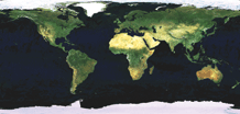

A large size image of the earth taken from space in 2004 has been donated to the UN Office at Geneva as a testimony of the state of our world today to be passed down to future generations. UNOSAT, the UNITAR operational programme for satellite applications, has brokered the donation through high level contacts with the European Space Agency, owner of the satellite ENVISAT that took the photograph. The picture is on permanent display in the Palais des Nations since May. Francesco Pisano, who coordinated the donation, explains to DIVA readers the details of this fascinating initiative.
Q : UNOSAT has brokered this donation from ESA, the European Space Agency. What is exactly this picture ?
 FP : The picture is a satellite image made of a mosaic of images taken from space. It shows the planet in its true colours so that one can see forests, deserts, mountains and oceans as they appear from space. The result is impressive, especially because the image is very large (4×8 metres). The mosaic is printed on plastic canvas and stands as much as a work of art as a demonstration of the evolution of satellite technology over the last decade. It is not just another image, it is a way to take stock of how our planet looks today and realise the importance of protecting our common world. This is why the United Nations is the appropriate keeper of this image. One day anyone will be able to see the difference in forest cover and desertification by simply looking at the image picturing our planet in 2004. It is a simple message but a compelling one.
Q : You have played a major role in this initiative. How was the idea was born ?

FP : As it often happens with good ideas, this one was the product of a rather fortuitous circumstance. I was taking part in the Earth and Space week last year in Brussels, organised by ESA and the European Commission, when I saw this particular very large image of the planet covering an entire side of the exhibition hall. I was stunned by its colours and sheer dimension : it looked more like an art painting than an ordinary satellite image. During a reception, I asked half jokingly to Steven Briggs of ESA whether he would consider making a present to the UN… and he accepted. The rest was about trading the idea within the UN and keep the project rolling. Here I found support from the office of the Director-General of UNOG and the collaboration of two inspired colleagues : Pierre Le Loarer and Anis Chibli. I worked with them for one year and together we turned the idea into reality. Of course our colleagues in ESA were very helpful. I should remind that this donation is entirely sponsored by ESA.
Q : One hears more and more of satellite applications being used, for example, in emergency relief coordination. Why is satellite imagery so important for the work of the UN ?
FP : Satellite imagery saves time and resources, it is objective and can reveal much more than what is visible to the human eye ; all this, in any weather conditions and any time. It helps to react quickly, assess accurately and plan wisely. It does not hold all the answers but eliminates a lot of time consuming questions. The UN cannot ignore these technologies having a direct positive bearing on the work of the international community. UNOSAT has promoted the use of these tools for years now and not only in humanitarian relief but also in disaster management and vulnerability reduction, early recovery, local capacity building. We believe in translating technology in usable applications to benefit the UN and above all those in need. ESA and its GMES programme are powerful allies of our in this undertaking.

Q : Can you give an example of useful applications outside the humanitarian sphere ?
FP : There are many. UNOSAT in particular has the merit of the first attempt to use satellite data gathered during the 1998 Hurricane Mitch disaster for recovery and longer-term risk reduction in Nicaragua, after the emergency response pahse. This widely known project, still producing positive results, has generated an entire family of similar applications. UNOSAT will soon launch a campaign to do the same in some 1,000 communities selected from hot spots at risk from natural hazards. It is a way to give substance to the recommendations of the UN World Conference on Disaster Reduction held in 2005 in Japan.
Q : Satellites do more than taking images of the earth. What else can be done today using satellite technology ?
Earth observation is in deed only one specialised area, but it one that is growing steadily. The importance of this area is enormous. Suffice to think of the sophistication of today’s meteorology. But satellites also support global positioning systems, telecommunications, and through these, telemedicine, internet, wireless telephony etc. I think that the most powerful applications for the future will be broad band internet connectivity via satellite. This is important especially in rural areas and in developing countries, for example.
Q : How do you feel now that this idea has become reality ?
FP : I am of course very proud of this initiative. I am glad that my colleagues from ESA, UNOG and the Director-General himself saw the inspiration of it and granted their support. For the rest I have to confess that I hope that one day my children could tell their own children how that picture ended up in the Palais des Nations in Geneva…


